
We could also see bits of glacier peeking out from under the clouds (possibly Skeiðarárjökull or Öræfajökull, both of which are part of the larger Vatnajökull glacier).

Traffic was starting to be sparse, and the two-lane bridges gave way to one-lane bridges (normal for the secondary roads, but previously unusual for the main highway), some of which were long enough to warrant multiple wider spots to facilitate slipping past opposing cars.


The view to the south was glacial runoff floodplains for miles, out to the ocean. As we got closer to the mountains, the weather steadily improved, and the view of the glaciers was incredible.


We arrived at the specified GPS coordinates (between two named farmsteads) for the puffin tour around 9:45 AM, somewhere near the village of Fagurhólsmýri (possibly the shortest Wikipedia article I've ever found).

It's telling, I think, that this road doesn't exist in Google Maps, despite being on our printed map that we have in the car.

We had some time before the 10:15 departure to survey the office, outhouse, and transportation options.


As we had now driven several more miles along the coast, the weather was once again cloudy with drizzle. Except now it was also extremely windy, too.

A few dozen brave souls, our group of four included, boarded the wagon (standing) and were towed a few miles through rivers, glacial silt floodplain, and volcanic ash flats, out to Ingólfshöfði.


Upon arriving at the gentler side of the cliff/outcrop, we de-wagoned and began the climb up the sand/ash hill. The guide helpfully informed us that "it is harder than it looks."


Once everyone reached the top, the guide mustered the troops and headed for the path along the cliff edge. But first, we stopped at admire the Ingólfur Arnarson monument.


While originally annoyed at the dampness and strong winds, we were delighted to discover that this was actually perfect puffin-sighting weather, as they retreat into their burrows when it gets too hot and sunny.


The guide encouraged us to spread out along the cliff, but also suggested staying away from the edge, as the puffin burrows might collapse underfoot and we're over 200 feet up. I believe her exact words were "stay away from the edge or you could die."
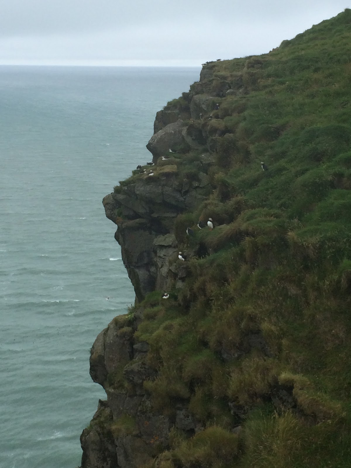

She also implored us to remain within sight of her, and to always be with at least one buddy, as there are aggressive-and-territorial birds of prey who may attack easy targets.

We toured around the top of the cliffs for about an hour, during which the rain stopped, but the wind remained.


There were some Very Serious Birdwatchers in the group. This guy was trying to get an in-flight photo, which was tricky since the puffins can apparently reach 50 mph.

The guide also had a birdwatching scope, and was happy to set up the perfect shot.


We eventually finished the circuit and returned to the wagon for our ride back to the parking area. The weather had improved remarkably during the hour we were up there, so the return trip was quite pleasant at the 10 mph pace.


Side note: there are some incredible photos of this tour/place in the Google image search results.
It was just after 1 PM as we left the puffin tour road/driveway, so we stopped for gas and lunch, at the same place.


In addition to lunch, this cafe helpfully sells all of the necessary supplies for vacationing in southern Iceland.

After sandwiches and skyr, we continued east along the ring road, towards our next stop: a boat tour of the glacier lagoon.

Enticed by a sign for "Glacier Lagoon Boat Tours", we turned off the road too early, by the tour location for Breiðárlón. Sabrina went to confirm that we were, in fact, at the wrong place, while I snapped some photos.


They are building some sort of more-permanent structure at this glacial lagoon, so perhaps there will be a new hotel or restaurant or something here, next time.

Just down the road, we found the correct glacial lagoon, Jökulsárlón.


It was just after 3 PM when we parked, and our pre-tour safety meeting wasn't until 3:50, so we had some time to survey the situation.


On the way in, taking pictures from the one-lane bridge seemed like a popular idea, so we hiked up there for a #selfie.


And a video.

Forgot to mention previously... these signs are all over the ring road, indicating wind speed and direction in the areas ahead, so you know if you'll get blown off the road, buried in a snow drift, etc. (probably more useful in the winter). This one either wasn't working, or there was no wind (unlikely).

We wandered along the shore, back towards the rally point for the zodiac tours.


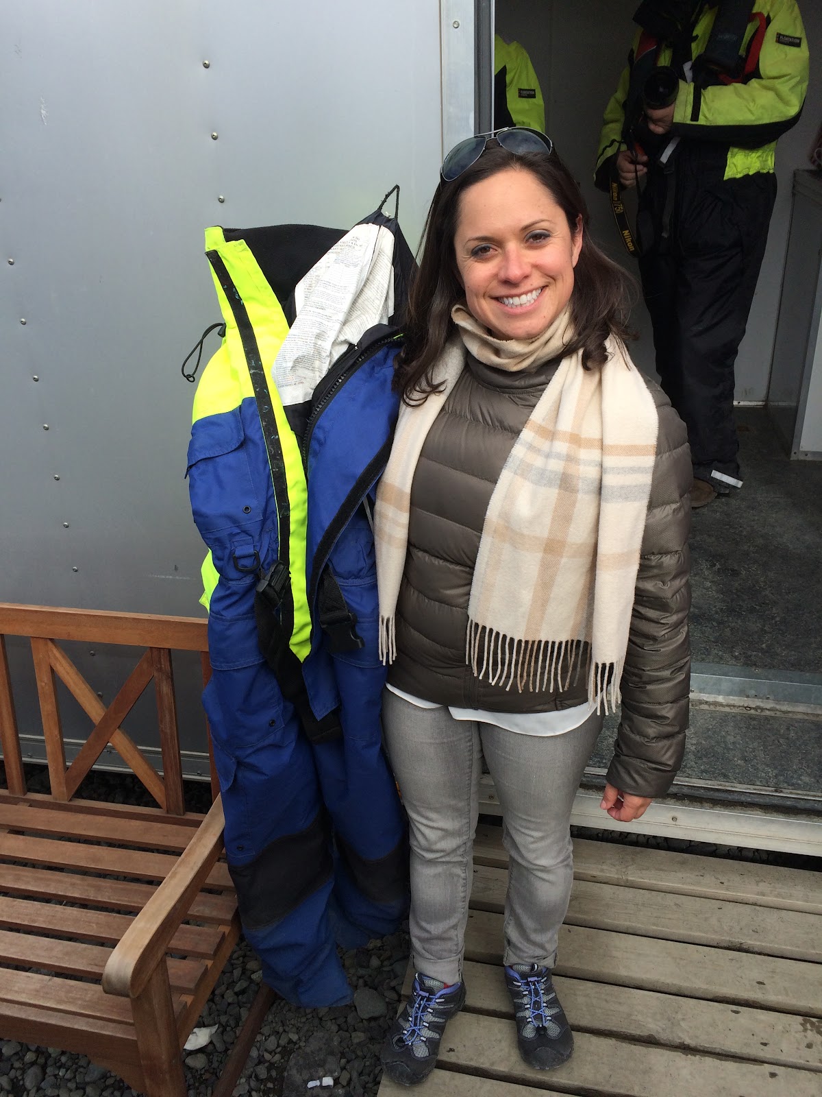
The amphibious (so-called "duckboat") tours looked (relatively) tame, but thankfully we had opted for the up-close-and-personal zodiac tour...


... which required survival/flotation suits, in addition to auto-inflating lifejacket collar things.

The safety instructions were simple and brief: always sit while the boat is moving, hold onto the rope, and if you fall in... don't panic. "It will be very cold, but we will come get you as soon as possible."


We made a brief stop to pick up a floating chunk of ice from the water. Our guide informed us that it was somewhere between 850 and 1000 years old, and we passed it around the boat.


We raced around the lagoon, dodging icebergs, towards the front edge of the glacier.

One of the icebergs was hosting a harbor seal, taking a break from fishing to sun itself and pose for photos.

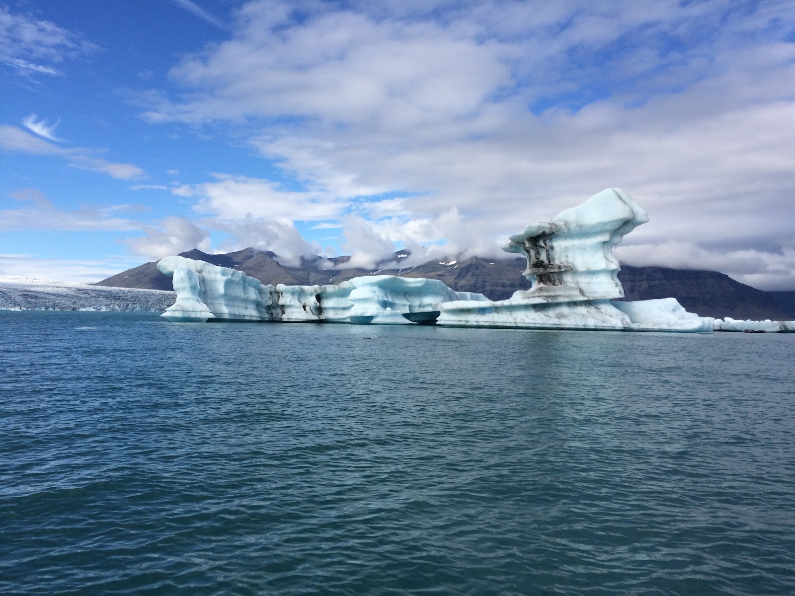

Eventually, we reached the glacier itself. While it looks close from the shore, it turns out to be about 5 miles from the bridge to the glacier wall.


We approached just in time to see a small iceberg calving into the lagoon. We drifted in front of the glacier for about 15 minutes, chatting with the guide, in case any more pieces decided to liberate themselves.
I asked him if anyone actually falls in the water. He assured us that he, personally, has never had someone go overboard. Furthermore, nobody had gone in the drink this year (so far), nor all of last year.
But the year before, they had 9 people fall in.
I suggested that he spin that as "safety is improving" and he countered with "it's that we've stopped hiring complete idiots."

Fortunate to have seen iceberg calving at all, according to our guide (I couldn't spell it, even if I could remember his name), we abandoned our post and returned safely (and quickly) to shore.

This is his summer vacation job, as he put it. In the winter, he's a fisherman in the northernmost town on the island. They essentially don't see the sun for four months at a time, up there.


The lighting was different by then, so we went back down to the water's edge for a few more photos.


Naturally, there was another couple taking (pre?) wedding photos. Although we couldn't figure out the US flag sweater.

By the time we left Jökulsárlón, it was nearly 6 PM, but we only had to return Geirland, about 90 minutes west.
Back across the bridge, on the other side of Rt. 1, we made a brief stop at the beach where the river meets the ocean to see icebergs stranded by the tide.


We also spotted another seal, heading upriver into the lagoon.

On the drive back towards the hotel, we stopped at a few locations I had marked on the map earlier in the day, just to take photos.


Plus a few more impromptu photo stops.


As we went farther west, the clouds returned.
Just east of Kirkjubæjarklaustur, we had one final stop at Dverghamrar ("dwarf crag" or "dwarf rocks").


We returned to the Hotel Geirland around 8 PM, and had a delicious dinner (I had the lamb burger... lamburger?).
After dinner, Sabrina and I went for a walk down the gravel road to see Stjórnarfoss. Along the way, we crossed a cattle grate, passed through a campsite, and were ignored by some horses.


We returned to our guesthouse just before 11 PM, and reviewed the plan for Day 6.
No comments:
Post a Comment