Saturday, September 2, 2023

Azores 2023 - Day 2: The Middle, So Many Stairs

As promised, we slept in this morning. The first order of business was to hit the Megasabor bakery again, next door to the building we're in, for some bread and coffee.

We had a vague plan to see a few sights in the central part of the island, including a stop at Lagoa do Fogo if it happened to be clear. Yesterday, the forecast for today was overcast and drizzly, but it was a clear morning.

As we headed east along the highway ring-road (EN1-1A), we could see the volcano in the distance, with only a few clouds clinging to the top.

Along the route, we looked for a place to stop and have a picnic lunch. There was another black-sand beach that looked promising, but when we stopped to view it from a distance, memories of yesterday's foot-roasting dissuaded us.


Instead, we stopped at a random road-side park (there are many) and lunched at a small table overlooking a lush ravine. There were a few families having serious cookouts that put our farmer's lunch to shame.

Google Maps identifies it as Parque de Merendas de Água de Alto ("High Water Picnic Park").

Winding along the coast road, we soon encountered Vila Franca do Campo.


We stopped for a break by the harbor, and beached the car on the sidewalk in front of a bakery, blending in with the locals.


After our snack, we tacked our way uphill to Ermida de Nossa Senhora da Paz (Chapel of Our Lady of Peace).


The view from the top was supposed to be excellent, and the chapel probably has some interesting history. I think all of the signs were in Portuguese though (understandably), so we didn't learn much.


The view from the top was, indeed, quite good. The small island just off the coast is apparently a tiny volcanic crater, and is a popular snorkel destination. I think there were boat trips leaving from the harbor, near the bakery we stopped at.


It is, of course, surrounded by hydrangea.


Back down the hill, we headed back toward the highway. This view of a narrow city street, with cars parked anywhere and everywhere, is fairly typical of what it's like to drive around the towns here.


In the dark ages before in-dash navigation, we probably would have stuck to the main roads to get around here. Thankfully, Google Maps is able to find delightful shortcuts like this one. I think there were more tractors on this road than cars.


We followed some rural roads across the narrow axis of the island, for maybe 8 or 10 miles, from the south coast to the north coast. Our next stop today was the Gorreana tea plantation.


The view out the windows, looking over fields of tea rows, was splendid and tranquil. The inside was a scene of absolute chaos, with throngs of tourists roaming around aimlessly, some taking guided tours, and others waiting in line to buy tchotchkes.


I caught the tail end of a tour, while Sabrina sampled some of the brewed tea. We decided to join the wandering horde, rather than wait for another tour.


I couldn't figure out if the equipment was actually still used for production, or if these were all just antiques. Some of it was belt-driven from a shaft on the wall, but also had modern safety cages, signs, etc.


We decided that the more interesting part of the experience was outside in the field, so we wandered around the rows of tea for awhile.


I almost lost Sabrina in the hedge at one point.


The weather was still cooperating, so we decided that operation Lagoa do Fogo was a go. From the tea plantation, it was only about a 15 minute ride to what-looked-like the place we needed to go.

En route, however, we made a detour to see Salto Do Cabrito. If you look carefully near the top of the opening in the rock, you can see a bridge (that is actually a pipe, going to the hydroelectric plant next to the parking lot for the waterfall).


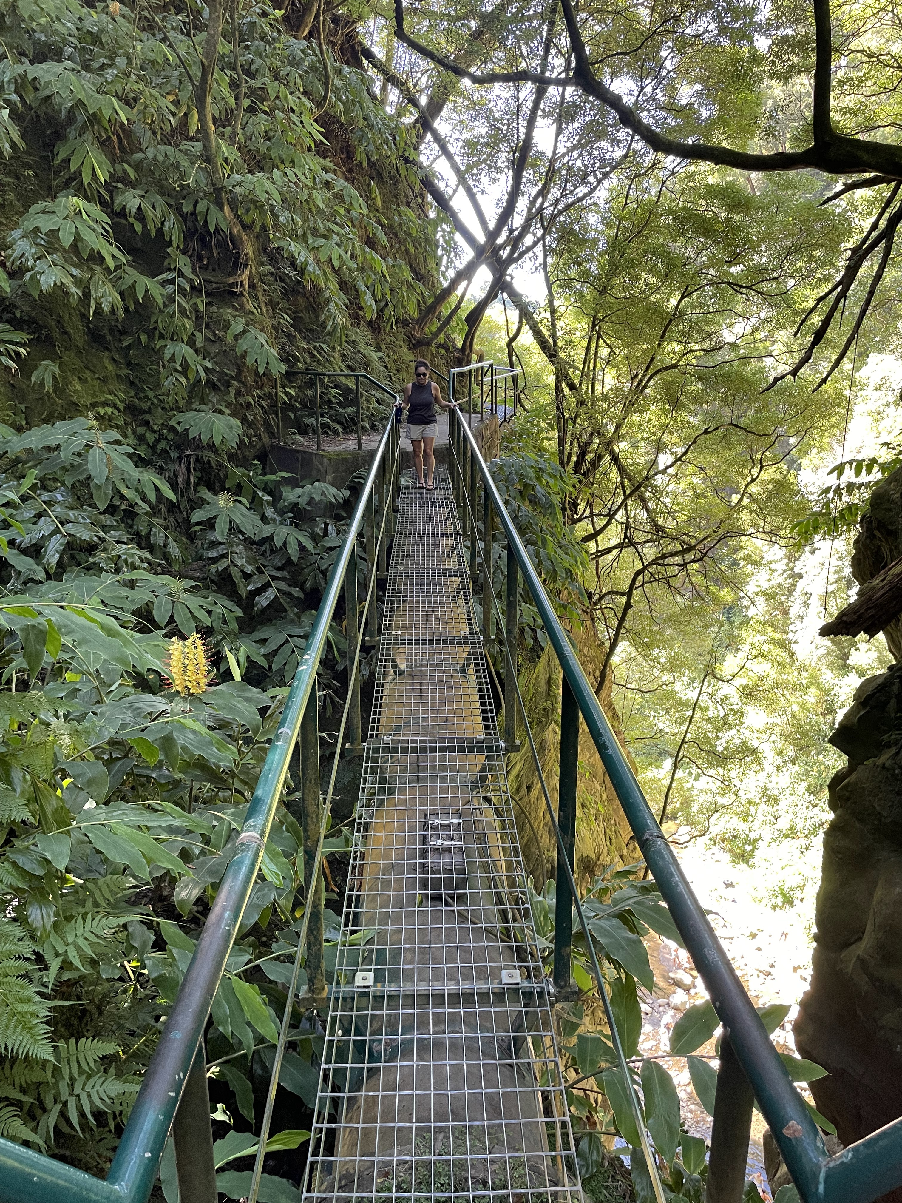
Obviously, we had to see where that trail went, so we legged it up the stairs behind the hydro plant and discovered that the trail is more like a service walkway, welded to the top of the pipe.


This is the bridge/pipe over the ravine, that we saw from below. Sabrina was not a huge fan of this part, or the previous part. Or the next part, really.


After walking along the top of the pipe for quite a way, and then alongside it for some distance after that, the trail ended at a pair of buildings that were related to the hydroelectric operation.

We returned the way we came, and continued up the mountain towards Lagoa Do Fogo.

Apparently we hadn't done enough research, because we were surprised to discover that the road to the top is closed to passenger cars between 9 AM and 7 PM, from June 15th to September 15th. Instead, we were diverted into the parking lot at the Centro de Interpretação Ambiental da Caldeira Velha and told that we had to take the shuttle to the top/crater/lake.

Unfortunately, a shuttle was just departing as we entered the parking lot. No problem, right? We figured there'd be another one shortly, which gave us some time to put on non-flip-flop footwear for possible-hiking, fill water bottles, etc. It also gave us time to try to figure out what the deal was with the shuttle, exactly. The only information provided was this sign:


Dissuaded by the part about "round trip time of 70 minutes", and realizing that it was already after 5 PM, we opted to temporarily ditch this plan and head down into Ribeira Grande for an early dinner, instead. We would then return after 7 PM.

On the way out of the parking lot, I stopped and asked the guard (cop?) for more details. He said the shuttle only comes about every 40 minutes, and the last shuttle departs the top at 7 PM. Knowing that, it would have been very difficult to avoid getting stranded up there, anyway.

I had previously found A Mulher de Capote liquor factory during trip planning, but had written it off for today because Google Maps suggests that they are closed on weekends, and their own website has no information about hours of operation, as far as I can see.

We happened to drive by it, however, on the way into town, and it looked extremely open to me, so we stopped for a quick tour.


It ended up being a private tour, probably because nobody realizes they're open on weekends.


At the end of the tour, we sampled several of their products at this tiny bar. It was a quaint little place, if a bit odd.


Anyway. We ended up "downtown", such as it is, where there seemed to be a few restaurants on a large square. Being on a bit of a tight schedule (to get back to the top of the crater just after 7 PM), we settled for the first convenient parking space and essentially picked a restaurant at random. They appeared to all be casual fare.

While we were vacillating, we were distracted by the odd sounds of a man piloting a horse-drawn cart down the street at an impressively quick pace. He appeared to be in a rush to get a barrel delivered.


I had to try the Barack Obama burger. I wonder what the story behind that is, and if he knows he has a burger named after him in a small town on the northern coast of São Miguel.


The pace of service being very much on Island Time here, it took a solid hour to get a bit of food and a beer sorted out. The sun was diving towards the horizon as we left, so we had to make haste.


We made it to the (free, now) parking lot at the viewpoint that overlooks Lagoa Do Fogo with plenty of time to spare.


In fact, it was a perfect place to relax and enjoy a sunset.


Instead of doing that, however, we impulsively decided to hike the trail down to the lake. We didn't have any water, hiking poles, or idea how far down it was, how long it would take, etc.


It turned out to be farther down than it looked from the top. A random man that was heading back up told us it was "450" when I asked him how many meters it was. I was skeptical, and also not thrilled if that was correct. Spoiler: I think it was 450 feet, not meters.


Down at the water, it was absolutely serene. We had the entire place to ourselves, with only the squawking of birds to break the silence.


Not wanting to hike up in the dark, we didn't spend too much time at the bottom. It took us about 15 minutes to descend, and 25 minutes to get back to the top. 


Back at the top, we were treated to a perfect sunset.


A short drive up the road took us to a scenic viewpoint where we could see the entire western end of the island, and the ocean on both sides, as the sun slipped behind the horizon around 8:30 PM. It was starting to get cold up there, so we didn't stay very long. It was only somewhere around 2200 feet of elevation, but it's been getting chilly here at night.


It was just after 9 PM when we got back to the apartment. Tomorrow, we are planning to do a more rigorous hike, see the eastern chunk of the island, and maybe visit a hot spring in Furnas.

Friday, September 1, 2023

Azores 2023 - Day 1: Red-eye, Sete Cidades

Our 10:55 PM flight turned into an 11:45 PM flight because the plane that pushed back, behind ours, had a mechanical problem with the engines and had to be towed back to its gate. The 100+ mph tailwind helped the pilots make up for lost time, though.

Around 1 AM (EDT), the flight attendants started dinner service, but were interrupted for about half an hour by turbulence. We ate the rolls, couscous salad, and the hot entrees, but saved the pretzels and cookies for later.


We were very close to the back of the plane, which worked out quite nicely as we were able to use the rear door to deplane quickly. We were off the plane by 4:45 AM (EDT), 8:45 AM local in Ponta Delgada.

Our bags came out fairly quickly, and customs/immigration was efficient and painless, so we were loading luggage into the VW Polo rental before 9:30 AM.


We had an hour or so to wait before we could get into our Airbnb, so we parked in some random spot downtown, intending to walk around. The pay station only accepted coins, which we did not have, and Sabrina wouldn't let me risk getting a parking ticket in our first hour on the island.

I don't think it was much of a risk, given how/where everyone parks here.

Instead, we meandered up the hillside near the Airbnb to the closest-of-three pineapple plantations that are open for visitors. Apparently there are over 6000 pineapple plantations on the island.


After wandering around for a bit and sampling some pineapple liqueur, we went to meet our Airbnb host and got a tour around the apartment.

The view from the corner balconies is wonderful, but mostly it was nice to grab a shower and unpack a bit.


As tempting as it was to take a nap, the best way to get over jet lag and a red-eye is to push through it, so we headed back out (after getting coffee and something to eat at a bakery around the corner).


It was a beautiful day, and we'd been advised to see the volcanic crater lakes whenever the peaks weren't shrouded in clouds, so we aimed for Sete Cidades, just to the west of Ponta Delgada.

Not knowing what to expect, we stopped at a few scenic viewpoints (miradouros) on the way up the volcano. There are viewpoints absolutely everywhere on this island, of varying parking-lot capacities, and they are all marked with signs so you have time to slow down without getting rear-ended.


The roads we were on today were mostly in good shape, and they drive on the right side here, so it hasn't been a steep learning curve like some of the other islands we've visited.


The roads are certainly narrow, windy, and sometimes steep, though, so it definitely involves some sporty driving. Sabrina loves that, fortunately. ;-)


A few clouds rolled in, which was a welcome sun shade; it was only 78F, but it's very humid here and the sun is relentless.


We parked by Lagoa do Canário (Canary Lagoon?), and joined the trickle of people following the trail up the hill to a Miradouro da Grota do Inferno (... Grotto of Hell viewpoint?).

But first, we took a short detour to see Lagoa do Canário. It wasn't particularly impressive, but was lined with huge hydrangeas. The entire island is covered in huge hydrangeas, though.


Along the trail, we got an up-close view (and smell) of the neighboring cows. There are cows everywhere on this island, too. I just looked it up, in fact: the human population of the Azores is somewhere around 240,000... and there are 125,000 cows.


The views from the top of the trail were spectacular, and the weather was perfect.


You can see Lagoa de Santiago in the foreground, and Lagoa Azul in the background. We drove down that road, soon after this.


The small one, on the left, might be Lagoa Rasa, I think?


Obligatory selfie. Who needs a selfie stick when you can just use your arm? People are confused when they ask if I want them to take a photo of us, and the answer is "no, thanks".


Sabrina is thrilled to "be in every photo", as you can see. In the very far background, some guy prepares to launch his drone, shortly.


Beware of cows.


There was another viewpoint, so we stopped again. The lake on the left of the road is Lagoa Verde. (So those two are "blue lake" and "green lake"? They can't all be creative names.)


It was around 3 PM as we passed through the town of Sete Cidades, and we needed another dose of caffeine (and a pastel de nata), so we stopped at a random bar/cafe to fuel up. Total cost: 3€ (about $3.25).


Back on the road, the hydrangeas loom large. In some places, they are tall hedges along both sides.


When we hit the western edge of the island, we turned and looped back around along the northern edge.


Along the way, we stopped in Mosteiros to see the beach and the islets just off the coast (you'll probably want to translate to English).


The (Google-translated) wikipedia page for the islets suggests that the town/region was named after them. If you look very carefully, you might be able to see the kayakers among the towers.


We'd seen black-sand beaches previously, in Hawaii and Iceland, but I didn't remember the sand being scalding hot; we tried to walk barefoot to the water, to avoid getting our flip flops covered in wet sand, but that turned out to be a mistake. Sabrina gave up halfway and put her shoes back on, while I stupidly ran to a wet part to soothe my burning soles.


Not far up the road, we stopped again at a park to take in views of the ocean. There was a protected sort of pool area, where people were swimming. I was surprised how calm it was, given that it's just the wide-open Atlantic. 


Back on the road, it was around 4:30 PM and Sabrina was fading again. She donned her neck pillow and caught a nap while I gently rocked the car back and forth along the scenic route. The CarPlay nav screen resembled this view quite often, today.


Someone was in a rush to get around me at one point, so I turned off the main road towards Capelas when I saw a sign that said "centro" with an arrow. Once in town, I followed some signs toward a miradouro, and ended up at Miradouro da Vigia, which Google Maps identifies as "Lookout viewpoint of Whales of the Chapels".

I climbed the stairs to the top of the lookout, took in the view, then woke Sabrina up so she could come see it too.


Having seen enough of the coast for today, we then headed straight back to the apartment to regroup. It was only about 20 minutes away.

Just as we were returning to Ponta Delgada, we made the executive decision to stop at a grocery store and acquire some meager provisions. The most promising choice was a Continente hypermarket (Portuguese page, again) that happened to be in a mall. By sheer dumb luck, I impulse-decided to follow a group of cars into what turned out to be a parking garage very close to the market.

It was sort of like going to a Target, with more food, on a Friday night, at the mall. In short: it was hectic. It didn't help that we can't read Portuguese and were exhausted; it took a very, very long time for us to figure out what the various options in the yogurt aisle were. They take their dairy very seriously here.

Back at the Airbnb, we unloaded our haul and began consideration of dinner options. Parking downtown looked like it was going to be quite an adventure, when we drove through earlier today, so we opted to navigate on foot for the rest of the evening.

By the time we had identified a few candidates and walked the ~1 mile, it was somehow almost sunset already.


Again, it being Friday night in the capital city, things were a bit crowded. We literally commented on the walk over that it was weird how empty and quiet everything was, until we hit the few blocks of proper "downtown" and found that everyone was doing exactly what we were: looking for dinner.

Our first two choices turned out to be a two-hour wait or completely full, so we ended up at a tapas restaurant that was only a 30 minute wait. I think it was almost 8:30 PM when we sat.


We almost started with the cheese plate, until we saw how large it was at a neighboring table. The waiter did not agree that it was too much cheese for two people, going so far as to add "I do not think it is too much... but I love cheese".

After dinner, we sampled the local pineapple for dessert.


It was 10 PM by the time we returned to the apartment, at which point we had a serious elevator discussion about how confusing it was to have to press "-" and "1" to get to the lower level, and what use the decimal point could possibly have.


Tomorrow, we're sleeping in. The weather forecast includes some rain, but I have no idea how accurate that is, here.